Bideford- Lundy- Ilfracombe- Barnstaple (continuation).
Day 4- Bideford to Lundy (30 miles at sea).
The thing is where do you start with Lundy? Surely this blog is a dialog of rides done, on this occasion an exception has to be made.
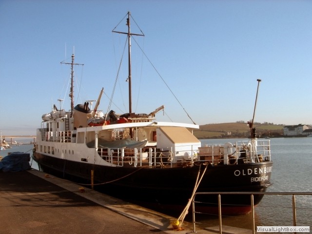 The MS Oldenburg was due to sail at 0900, but the ticket recommended we be there at 0800 ready for boarding.
As no
bikes are allowed on Lundy, we pre-arranged with the Landmark booking office to leave our cycles on the ship until
we sailed back, but I guessed what the pre-planned (and agreed) outcome would be; all the ships crew denied
having any knowledge of storing the bikes on the ship. There was even a conflict in opinions with some of the
crew. Eventually, we put them on board (it was more complicated than that, but I won’t bore you with the discussion).
The ship left on the full tide exactly at 0900, on a bright, but slightly cold day. The first thing on the agenda was breakfast, the galley held a selection of pastries including one that resembled a bacon wrap and of course; coffee. As we made way out of the river Torridge estuary, we passed a warship on the left, to the right was sand bars with what looked like other military landing craft. In fact the long sandy beaches around the Bideford area were extensively used by the Americans to rehearse for the D-day landings in 1942/44. Once out into the open sea, MS Oldenburg picked up speed and the blustery weather dipped the temperature further, even though the sun was out. The next sight we saw of land was Lundy in the distance.
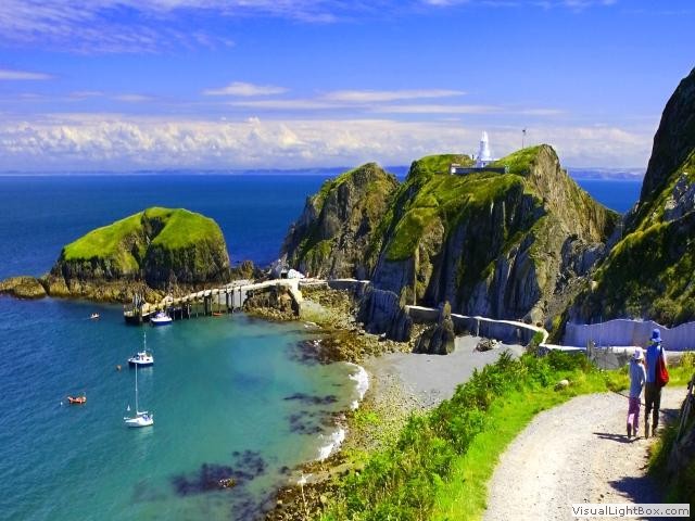 Where the Atlantic Ocean meets the Bristol Channel with nothing between it and America lies the island of
Lundy off the coast of North Devon. It is a granite outcrop, three miles long and half a mile wide. In the
hubbub of the modern world it is a place apart, peaceful, and unspoilt. Throughout the centuries Lundy has
had different owners and been used for everything from granite quarrying to a haven for pirates. We left the
ship and climbed the mile long causeway, heading for the Marisco Tavern, the only pub on the island. After a
few pints, naturally we needed a wee, and I have to say the urinals have to be the best view I’ve ever seen
(from a toilet). It was time to head for our accommodation, passing St. Helena’s church.
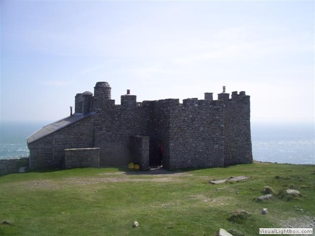 We were staying in castle keep east, a real castle over 400 years old. The keep is now split into three
comfortable cottages. The kitchen has every tool a gourmet chef would need (except a microwave), up a
winding stairs is the lounge, snug and sociable with a small bookcase containing all the reading material
one would need for a few days. One of the books is a diary of people who have stayed there before, some
people have written essays, others just a signature, but most entries had something in common; the Wenlock
fire, a small multi-fuel cast iron Aga. Less than forty years ago, more or less every house in the UK had a
coal fire, as a young lad I can remember my mother lighting it most days. Now the modern generation can’t even
start a coal Aga, even with fire lighters. Castle Keep East looks inward into a small courtyard, except for
two windows in the outer walls which have spectacular marine views.
Day 5- Lundy (8 miles walking, just a guesstimate)
I’m not sure about ghosts, I like watching the programmes, but I’m sceptical. I didn’t sleep well, and yet the place was warm, tranquil, and comfortable, it’s just in a 400 year castle, I was expecting something to walk through the wall at any moment. My fears were unsubstantiated.
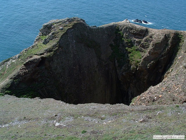 We set off the next day, in our walking gear. Our plan was to circumnavigate the small island. Starting
off on the South west point of the island, we came across a huge hole; the Devil's Limekiln is a sea cave
and is formed primarily by the wave action of the sea. The Devil's Limekiln is also open to the air, following
the collapse of it's roof and is a good example of a littoral sinkhole. Just after studying my guidance map of
the island, it showed Goat island to the left, not strictly an island but defiantly loads of goats.
Lundy has three walls dividing the island, quarter, halfway, and of course three quarter wall, not very imaginative names, but at least you know where you are. Just before quarter wall is the old lighthouse, the highest in Britain, but being high doesn’t necessary mean you would seen out to sea. Lundy’s fogbanks roll across the island obscuring the light. In an attempt to solve the problem of shipwrecks on Lundy in fog, a signal station was established low down on the western cliffs in 1862. Two families were employed by Trinity lighthouse to fire two cannons which boomed a blank shot every ten minutes. These were replaced by rockets in 1878, the site was abandoned when the North Light and South Light were constructed in 1897. The remains of the western cliff battery is still there.
We climbed over Quarter wall and followed the path, and I have to say- one thing Lundy isn’t short of is shit. There's a selection of goats shit, deer shit, sheep shit and rabbit shit. Not to mention Twitcher's, Archaeologists, and tree huggers (not suggesting that their shit is on the path) huddling together around each peninsular. Just along from quarter wall was a gaggle of twitcher's with telescopic cameras and tartan flasks a ready. So as not to disturb them we took a wide path around them. There's lots of landmarks labelled 'devils' something, as well as rocks named after saints, the scenery is rugged and dangerous, there are no fences or warnings, one slip and you're down, and considering most of the island has no mobile phone coverage; your dead.
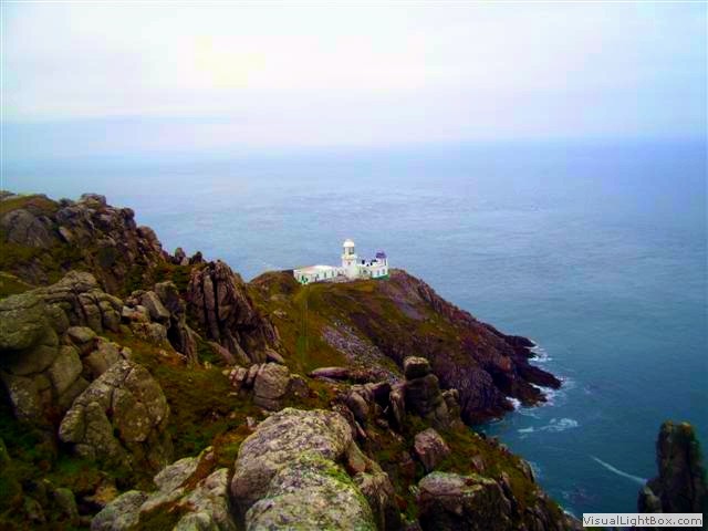 We continued along the west side eventually climbing three quarter wall, this part of the island is
desolate and boggy, one could be wading through any moor on any highland. We finally had to head for
the only road on Lundy (not tarmac) and continued north, until the next step we took, would have needed
flippers. There is a visible small track to the left which was once a tram track down to North Lundy
lighthouse. We sat on Constable rock and observed the Puffins bobbing around in the water (we presume
they were Puffins, anyway we were in the right place to see them). I felt we deserved an ice cream, but
there was no one to be seen. We started heading back on the East coast path and passed the remains of a
house, now a pile of rubble. Then after crossing three quarter wall there was Tibbetts, a lookout post
in WW2, now another self catering cottage. Tibbetts was built on the second highest point of the island.
It is said fouteen lighthouses can be seen from it on a clear night. Because of its distance from the
village, Tibbetts is the only property that has no electricity.
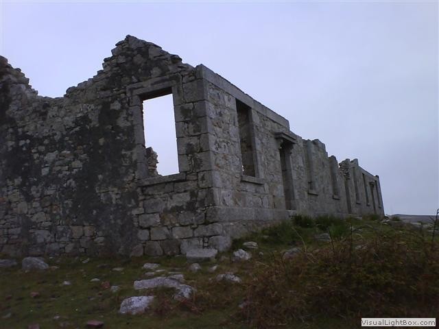 After the halfway wall, was yet again another derelict building, more substantial than the previous
piles of rubble. These houses were built by the Lundy Granite Company in the 1860s for the company
surgeon, the engineer, and the foreman of works. There was also a hospital built by the same company
together with a surgery (which did not survive) in a walled enclosure to the north of the Quarry
Cottages. The weather had now turned and began to rain heavily along with a cold dense fog. We decided
to head back to the tavern and have a swift half or two then retire to the cottage and dry off.
Day 6- Lundy to Ilfracombe (32 miles at sea).
The weather had closed in; we could hardly see the lighthouse out of the lounge room window. The fog rolled past the window like puffs of steam and combined with the smell of the Wenlock coal fire, the senses could be fooled in to believing we were on a station with a steam train waiting at the platform. Today was the day we were meant to sail back to the mainland and I have to say I was quite disappointed we had to leave the cottage at 1000 as the boat back left at 1600, we had a lot of time to kill. My chum decided to go for another walk, but probably because of my early cycling career I find it easier to cycle than walk, I declined. I headed for the Tavern, but had to quickly escape the building when a crowd of geology students piled in to the pub, encroaching on my space. I was frightened they would want to converse with me about rocks, as a subject goes, I would prefer to discuss how to make wall paper paste than talk about rocks.
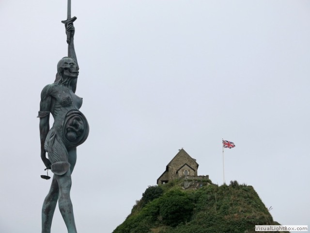 When we finally headed for the boat, it was 1530. We boarded and checked the bikes, at 1630 we were on
our way. The weather gave us calm seas, but emptied the clouds all the way back. We were due in at
Ilfracombe at 1830, on the approach the first thing we seen of the port was a statue of a pregnant woman
holding a sword, as we came closer it became apparent this was the most ugly, out of place statue I'd ever
seen, displaying a cross-section of the mum and foetus.
We would have rode to Barnstaple that night except the last train left at 1800, so we stayed at Ilfracombe. We stayed at the Imperial hotel and though there was a coach party booking in just before us, the receptionist was efficient and courteous, and told us where to store our bikes. We showered and changed, heading out on the town for food. We ate at an Italian restaurant and to be fair, I was unimpressed. Back at the hotel, a bonus of having a coach party at a hotel is the evening's entertainment; bingo and a singer. It was a good night.
Day 7- Ilfracombe to Barnstaple (16 miles).
In the morning we had porridge and set off, it was cold, but dry. Within a mile of Ilfracombe we ascended up and up, the resurfaced track bed of the old railway runs past the western slopes of Cairn and now forms the first part of theto the NCR 27, once on the path it was a little more progressive, but still up hill. I could see the reason why they had two engines on the train when the railway line was open, one on the front and one on the back. It ascends though a valley and then through a small tunnel. No sooner had we started to descend and the path stopped forcing us onto the road. We carry on climbing a gentle ascent, until finally we descend with views of Barnstaple in the distance.
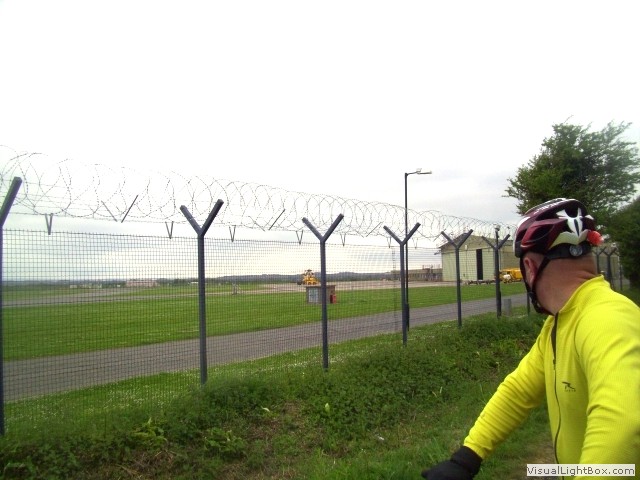 After belting down a steep descent into Braunton, we had to slam the anchors on and nearly overshot the
entrance to the next section of the railway track path. The path follows the river Taw and past Chivenor
Royal marine's base. We stopped to take a photo of the RAF Sea-king rescue helicopter at the base. At
Barnstaple we visited the leisure centre to have a shower, they kindly stored the bikes in their office.
Seven days away, the first two full days riding were very enjoyable, then Lundy. A lady asked me would I go there again. Probably not, as there are many Landmark properties worth a visit. Would I recommend visiting Lundy? Yes. Would I stay at a Landmark property again? Definitely. To finish we rode from Ifracombe to Barnstaple, a good ride, but broken by a fair section on roads. This was an epic journey, but as an explorer I don't like to visit the same place twice, there's so much more of the UK to survey.
-
Gallery
 Why not have a look at the gallery relating to this ride. Click the image or the title.
 -
The MS Oldenburg
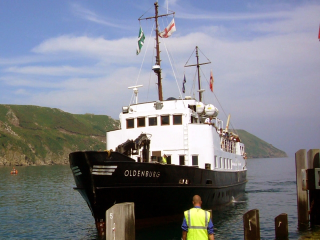 The MS Oldenburg serves the island of Lundy and was named after the former grand duchy of Oldenburg,
Germany, she was launched in 1958. In November 1985 she was sold to the Lundy Co. Ltd. to replace Lundy's
transport boat, the Polar Bear. After a refurbishment at Appledore Shipyard and receiving new engines in
1986, she began her journeys for passengers and supplies to the island.
 -
Puffins on Lundy
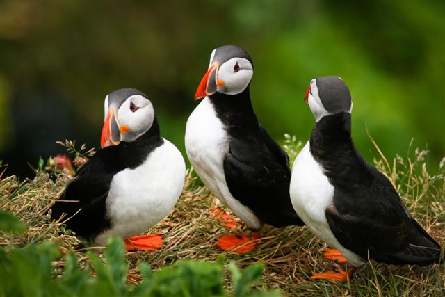 Lundy island has been designated as a Site of Special Scientific Interest and it was England's first statutory
Marine Nature reserve, and the first Marine Conservation Zone, because of its unique flora and fauna. It is
managed by the Landmark Trust on behalf of the National Trust. As an isolated island on major migration routes,
Lundy has a rich bird life and is a popular site for birdwatching, with a popular bird; the Puffin. Puffins have
a brightly coloured beak during the breeding season. These are seabirds that feed primarily by diving in the
water. They breed in large colonies on the coastal cliffs, nesting in crevices among rocks or in burrows in
the soil.
 -
Marisco Castle
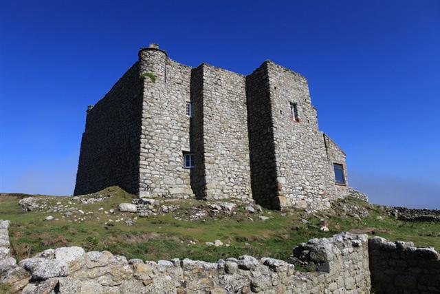 In 1238, an attempt was made to kill Henry Ⅲ by a man who later confessed to being an agent of the
Marisco family. Now implicated in the assignation attempt, William de Marisco fled to Lundy
where he virtualy lived as a king. He built the stronghold
on the island known as Bulls' Paradise which had nine feet thick walls. In 1242, Henry Ⅲ sent troops to
the island. They scaled the island's cliff and captured William de Marisco and sixteen of his "subjects". Henry
Ⅲ built the current castle (sometimes referred to as the Marisco Castle) in an attempt to establish the rule of
law on the island and its surrounding waters.
 -
Lundy pirates
 Over the next few centuries, the island was hard to govern. Trouble followed as both English and foreign
pirates and privateers – including other members of the Marisco family – took control of the island for
short periods. Ships were forced to navigate close to Lundy because of the dangerous shingle banks in the
Bristol Channel. This made the island a profitable location from which to prey on passing Bristol-bound
merchant ships bringing back valuable goods from overseas.
In 1627 Barbary Pirates from the Republic of Salé occupied Lundy for five years. The North African invaders, were under the command of Dutch renegade Jan Janszoon. From 1628 to 1634 the island was plagued by pirate ships of French, Basque, English, and Spanish origin. These incursions were eventually ended by Sir John Penington, but as soon as Government forces ended the pirates reign and left the island, the Pirates took control again. In the 1660s and as late as the 1700s the island still fell prey to French privateers. -
Heinkel He 111 bomber remains
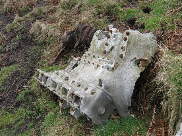 During World War II two German Heinkel He 111 bombers crash landed on the island in 1941. The first was
on the 3rd March, when all the crew survived and were taken prisoner. The second was on the 1st April when the pilot
was killed and the other crew members were taken prisoner. The plane had bombed a British ship and one engine
was damaged by anti aircraft fire, forcing it to crash land. A few remains can be found on the crash site.
Reportedly to avoid reprisals the crew concocted a story that they were on a reconnaissance mission.
 -
Lundy Granite Company
The quarries were excavated by the Lundy Granite Company from 1863-68 and were linked by a tramway which ran along a terrace cut into the side of the island. Another tramway traversed the incline lowering the stone to the quay and jetty, it had an unusual brake drum controlling the descent by use of ropes.
In one of the quarries to the north is a memorial to John Pennington Harman, awarded a posthumous Victoria Cross for his actions at Kohima in Burma in 1944. The quarry, now known as VC Quarry was one of his favourite places when he was a boy on the island. -
Verity
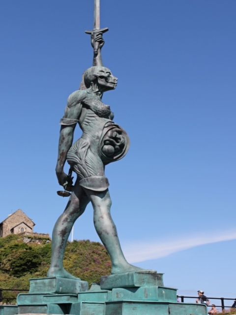 The statue called Verity shows the internal anatomy of the pregnant woman, with the unborn baby, she
stands on law books and holds a sword high. The local reaction was very mixed, critically calling it
'ugly' and stated that 'it wasn't suitable for a Victorian seaside town'. The council received hundreds
letters from people who objected to the installation of the statue. Despite the oposition councillors
announced the statue had a "tremendous effect" with people visiting the town solely to see Hirst's
work. I think it's absolute shite.
 -
Dotto Train
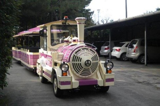 A new train service started in Ilfracombe last year, but it's not attached to the mainline. In the
1970's the line from Barnstaple to Ifracombe was shut under Beeching's axe, there has been talk of
reinstating the line at part of the way to Barnstaple, though most of it has been developed
and built upon. The new train service aforementioned is a land train and has proved successful
amongst tourists, it just doesn't cut it for me though.
 -
End of an era
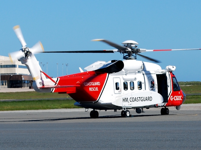 The UK's helicopter search and rescue (SAR) teams are to be privatised, the US-based Bristow Group
has won a ten year, £1.6bn contract to run the service from 2015, ending seventy years of RAF
and Royal Naval operations. For the South West of England, it means operations at Royal Marine
Barracks (RMB) Chivenor will relocate to St Athan in Wales, and work at Royal Naval Air Station
(RNAS) Culdrose in Cornwall will move to Newquay Airport.

 The MS Oldenburg serves the island of Lundy and was named after the former grand duchy of Oldenburg,
Germany, she was launched in 1958. In November 1985 she was sold to the Lundy Co. Ltd. to replace Lundy's
transport boat, the Polar Bear. After a refurbishment at Appledore Shipyard and receiving new engines in
1986, she began her journeys for passengers and supplies to the island.
 Lundy island has been designated as a Site of Special Scientific Interest and it was England's first statutory
Marine Nature reserve, and the first Marine Conservation Zone, because of its unique flora and fauna. It is
managed by the Landmark Trust on behalf of the National Trust. As an isolated island on major migration routes,
Lundy has a rich bird life and is a popular site for birdwatching, with a popular bird; the Puffin. Puffins have
a brightly coloured beak during the breeding season. These are seabirds that feed primarily by diving in the
water. They breed in large colonies on the coastal cliffs, nesting in crevices among rocks or in burrows in
the soil.
 In 1238, an attempt was made to kill Henry Ⅲ by a man who later confessed to being an agent of the
Marisco family. Now implicated in the assignation attempt, William de Marisco fled to Lundy
where he virtualy lived as a king. He built the stronghold
on the island known as Bulls' Paradise which had nine feet thick walls. In 1242, Henry Ⅲ sent troops to
the island. They scaled the island's cliff and captured William de Marisco and sixteen of his "subjects". Henry
Ⅲ built the current castle (sometimes referred to as the Marisco Castle) in an attempt to establish the rule of
law on the island and its surrounding waters.
 Over the next few centuries, the island was hard to govern. Trouble followed as both English and foreign
pirates and privateers – including other members of the Marisco family – took control of the island for
short periods. Ships were forced to navigate close to Lundy because of the dangerous shingle banks in the
Bristol Channel. This made the island a profitable location from which to prey on passing Bristol-bound
merchant ships bringing back valuable goods from overseas.
 During World War II two German Heinkel He 111 bombers crash landed on the island in 1941. The first was
on the 3rd March, when all the crew survived and were taken prisoner. The second was on the 1st April when the pilot
was killed and the other crew members were taken prisoner. The plane had bombed a British ship and one engine
was damaged by anti aircraft fire, forcing it to crash land. A few remains can be found on the crash site.
Reportedly to avoid reprisals the crew concocted a story that they were on a reconnaissance mission.
 The statue called Verity shows the internal anatomy of the pregnant woman, with the unborn baby, she
stands on law books and holds a sword high. The local reaction was very mixed, critically calling it
'ugly' and stated that 'it wasn't suitable for a Victorian seaside town'. The council received hundreds
letters from people who objected to the installation of the statue. Despite the oposition councillors
announced the statue had a "tremendous effect" with people visiting the town solely to see Hirst's
work. I think it's absolute shite.
 A new train service started in Ilfracombe last year, but it's not attached to the mainline. In the
1970's the line from Barnstaple to Ifracombe was shut under Beeching's axe, there has been talk of
reinstating the line at part of the way to Barnstaple, though most of it has been developed
and built upon. The new train service aforementioned is a land train and has proved successful
amongst tourists, it just doesn't cut it for me though.
 The UK's helicopter search and rescue (SAR) teams are to be privatised, the US-based Bristow Group
has won a ten year, £1.6bn contract to run the service from 2015, ending seventy years of RAF
and Royal Naval operations. For the South West of England, it means operations at Royal Marine
Barracks (RMB) Chivenor will relocate to St Athan in Wales, and work at Royal Naval Air Station
(RNAS) Culdrose in Cornwall will move to Newquay Airport.