The Biddulph Valley Way over the Peak District to Hulme End junction. (2 days riding- 36 miles +).
 I came across a picture of Alton station (in staffs) whilst looking for another image and thought
'I have to ride past this'. Alton station is an epitome of most Hornby model ‘OO’ gauge stations that every little
boy wanted for his train set, the real building is on the Churnet Valley trail and is now owned by Landmark Trust
and can be hired to stay in. The trail starts at Oakamoor and finish’s at Denstone and is only 4 miles long,
not long enough to travel half way across the country to ride such a short distance, so I backtracked on
Google maps and ended up discovering two full great days of riding leading to Alton, but the rides didn’t go
as planned, by the end of the second day, I was sat in a hospital bed.
Day 1. Newport to Stoke-on-Trent (Train + 6 miles riding to camp)
After 3 hours of travelling to Stoke-on-Trent on the train, I didn’t want ride another four hours to my first stop. As always I wanted to keep the costs down, but there were no campsites in Stoke-on-Trent, so just to put a twist on the journey, a colleague of mine suggested I try stealth camping (which would be my first time), but (and no disrespect meant) I looked at the area on the internet and saw boarded up premises, sending a wave of reservation through me, after some discussion and reassurance from my colleague, I decided to try it.
I travelled late in the evening, just leaving enough time to ride to a pre-planned
place, erect the tent, and have a tea before the sun set (in theory). I left the station and looked back at
this magnificent building silhouetted by the dropping sun. The grade II listed railway station has to be one of
the best examples of early Victorian splendour built in the style of a Jacobean manor-house. Opposite the
station is a statue of 'Josiah Wedgwood', late in the eighteenth century Wedgwood created a new light blue
earthenware which impressed the then British Queen.
 Out of the station I turned right and over the canal and main railway following the NCR 5 signs, onto the
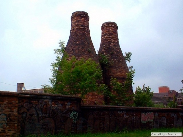
Trent and Mersey canal, past a couple of locks and past two of the few remaining bottle ovens left, Stoke-on-Trent's
skyline was once dominated by 1000's of smokey bottle kilns. A little way on, the Caldon canal meets the Trent and
Mersey canal. Sandwiched in-between the two canals is the Etruria museum, even though it wasn't open this time of
night, I crossed the canal over a little footbridge to see the place. In the centre of the canal
was a statue of canal engineer ‘James Brinley'. Back on the Trent and Mersey, Festival Marina appeared on the right
full of multi-coloured canal barges now all lit up as darkness began to cloak the horizon. I had to cross over here to
continue along the canal as the path ends on my current side, then back over a little further on. I passed by
several former factories now only scars on the land as all the buildings had been demolished. The area looked like
it had never recovered from the boom years of full employment. I turned off the canal at Westport lakes.
There are two lakes at Westport, I headed for the smaller of the two, through a gate and began setting the tent up, now it was pitch black. I had a superb front light, so it wasn’t a problem. It started to rain and I found out I wasn’t the only camper in the field, a French couple came across and asked me if I needed help. In 10 minutes the tent was up and I had a brew on, then bed. The night was loud with thunder and rain, trains rushed past, but I eventually fell asleep.
Day 2. Stoke-on-trent to Congleton to Hulme end tea junction (28 miles)
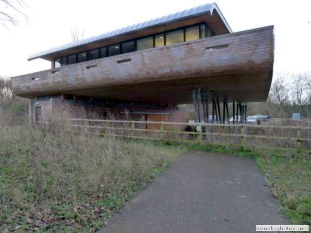 At first light, it was still pouring down, but I had all day to get to Hulme End, so I turned over and
nodded off again. At ten o’clock I packed everything away and headed for the onsite lake cafe. With awesome views
over the lake, I indulged in some tea and toast and was set for the day. There were lots of tarmac routes leading
out of or around Stoke-on-Trent, but they were too short and crossed loads of roads, the one I chose was
speckled with dog crap and had become an obvious dumping ground for the locals televisions and mattress’s.
Following the sat nav it turned me back onto a main road, finally I turned off the road and passed a
single rail bogey on the side of the path, I presume this was the
start of the Biddulph Valley Way proper. There was a big sign suggesting off road motorcyclists would be
prosecuted, to complement this, high on the hill side were a series of cameras on tall masts, reminding me
what Derry (or Londonderry) in Northern Ireland looked like in the eighties 'troubles'. Just across the valley
was Chatterley Whitfield colliery, I crossed the bridge in torrential rain to take some pictures before
rejoining the cycle route.
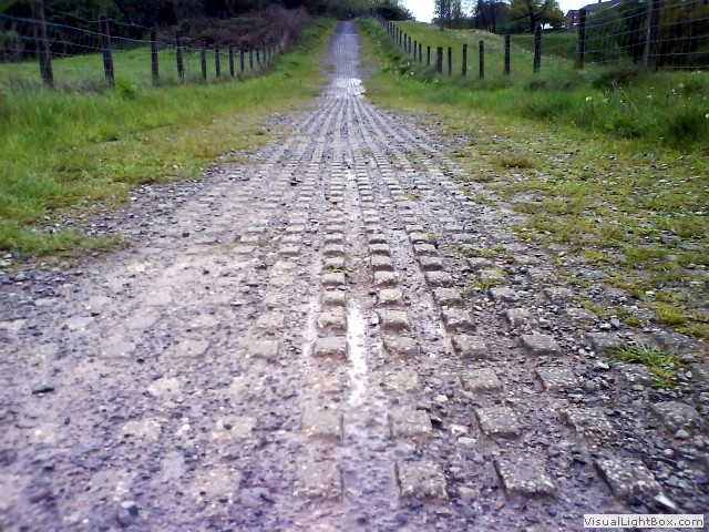 I know cycle paths vary in quality, but I believe this one was meant as a
punishment to cyclists. Each road crossing had those ‘v’ shaped barriers, designed to obstruct motorbikes
(unfortunately, they obstruct cyclists too). Then there was a steeped stepped access to the next part after
crossing another road. Worse was yet to come; down a hill and without warning was a concrete section best
compared to the perimeter of supermarkets, where they put mini-tank traps to prevent people stealing trolleys.
My wheels followed the groves, unsettling my front pannier which dislodged from its mounts, I came within a
pinch of salt of coming off. The path was now crushed gravel and full of puddles, the problem with puddles
is there could be a dirty great big hole under them, it poured down and the sound of grit in the discs brakes
increased.
I left the Biddulph Valley Way at Congleton and in my opinion not a moment too soon. I unexpectedly began climbing on Dial Lane (I knew there was a big climb later) and later Beat Lane, I looked back, the views were immense. Congleton viaduct stood out from the background with a fuzzy Jodrell Bank Observatory to the right. After a short descent I turned off onto a permissive path of the old North Staffordshire Railway, the NSR was formed in 1845 to promote a number of lines for the Staffordshire Potteries and coal mines.
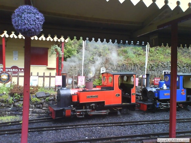 The path now follows Rudyard lake, the lake lies in a fold of thickly wooded hillsides, and is reminiscent of
Bassenthwaite in the lake district, I imagine it’s quite nice here in the summer. The two and a half mile
long lake was created more than two centuries ago to supply water for the then expanding canal system of the
West Midlands. A narrow gauge railway now takes up some of the route of the old NSR and runs all of the way
along the lake, past the dam and into its terminus two miles from Leek. It was shut today, but had one engine
in steam for maintenance. The path stops at Leek, and continuing the theme of cycle paths in Staffordshire,
it’s up a load of steps (no mean feat with a fully kitted bike). Tea and a bun helped perk me up on this
miserable day, ready for the next leg of my journey; a climb of over 900 feet in five miles over 'the
Roaches escarpment' in the Peak district, 1500 feet above sea level.
Some parts were incredibly steep, too steep to ride forcing me to walk, the elements threw their worst at me, taunting me to quit, but I got there. Imagine my euphoria when I reached the top, only the army and a few passing cars were brave enough to come to this desolate place so near to the edge of the ozone layer. I was positively buzzing when I turned right at the Mermaid Inn, I was singing away to myself as the sun came out to congratulate me, as I descended at forty miles an hour into Warslow. I had 3 miles to go for the campsite at Hulme End, when unexpectedly my front pannier came loose, jammed in the front wheel, hurtling me through the air, which only had one outcome; I hit the black stuff hard and skidded on my back for twenty yards.
 The front pannier had disintegrated and had strewn my belongings all over the road. Apart from some
shoulder pain, I seemed to be intact, so I sat up and surveyed the scene; to add insult to injury a few crows
landed beside me and started eating my ginger nut biscuits. I spoke to them, "thanks for your concern guys,
I think I’m alright," but they just bounced twice on their feet and flew off with my gingers. I stood up and
gathered my battered belongings off the road, a neighbour who had seen the crash (apparently it was a spectacular
crash) had already called for an ambulance. I left the bike with the lady who called the ambulance and went to
hospital. The ambulance took ten minutes to descend back down the mountain into Leek, the same climb that previously
took me an hour and twenty minutes to climb up on my bike in the opposite direction, I felt robbed. The xray showed
a broken collar bone, with a few fractured ribs thrown in for good measure
I didn’t get to ride past Alton station, but I did the first leg of the journey; the Biddulph Valley Way, and my opinion of that; don’t bother. Some parts of the route were obstructive and other parts were downright dangerous, back at Stoke-on-Trent, I believe the mini tank traps had damaged the front pannier receptacle, making it vulnerable to failure (this had never happened before), only the latter part of the route near Congleton could be described as enjoyable. It amazes me that some cycle paths are only suitable for mountain bikes, but the irony is; true mountain bikers usually stick to mountains. Those that ride longer distances don’t generally use mountain bikes, only a minority of people would use mountain bikes on a long distance path; so who are they aimed at?
I will finish the trails, but I will more likely approach the Manifold Way and then the Churnet Valley trail from Cromford following the 'High Peaks trail' northbound. Depending on how well the injury heals; that’s going to be between five weeks to eight weeks time.
-
Gallery
 Why not have a look at the gallery relating to this ride. Click the image or the title.
 -
Alton station
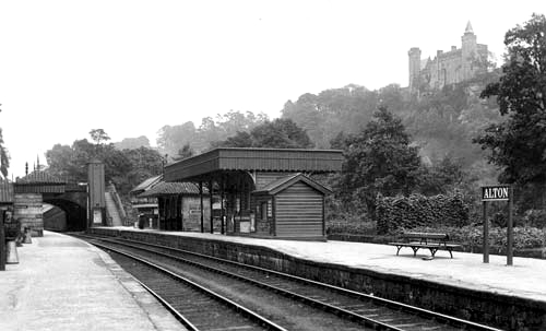 Alton station was built in an Italianate villa style in about 1849. The station was used by the Earl
of Shrewsbury, and had a luggage lift to hoist the Earl's baggage up to the entrance to Alton Towers.
The station also comprised a three-storey tower which contained the Earl's suite of waiting rooms and its
platform was particularly long to satisfy the Earl's desire to have impressive surroundings in which to
receive his guests. In 1954 the station was renamed Alton Towers. After the line closed in the 1960s, the
station was acquired by the Landmark Trust.
 -
Smokey Stoke-on-Trent
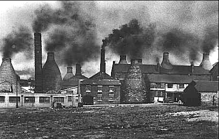 Since the 17th century, the area has been almost exclusively known for its industrial-scale pottery
manufacturing. Companies such as Royal Doulton, Dudson Ltd, Spode, Wedgwood, Minton and Baker & Co.
were established and based there. The local abundance of coal and clay suitable for earthenware production
led to the early development of the local pottery industry. The construction of the Trent and Mersey Canal
enabled the import of china clay from Cornwall together with other materials.
 -
Westport Lakes
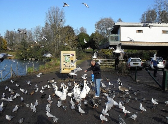 Westport Lake used to be the site of Port Vale football club. The ground was originally Westport
Meadows, the club played there for three years, but the area was prone to flooding. Today there are
two lakes, with a path a mile long around them, the lakes provide a sanctuary for visiting birds from
all over the World.
 -
Brunswick Wharf
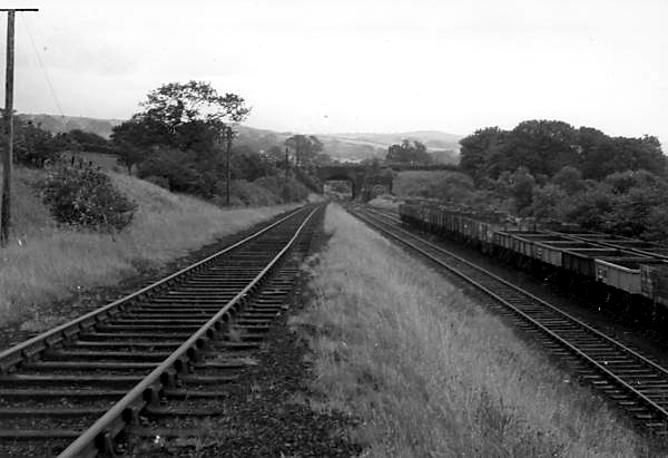 For over 100 years trains travelled along the Biddulph Valley Way carrying coal from the Collieries
around Stoke-on-Trent to Congleton. The railway line linked Stoke on Trent to Brunswick Wharf in
Congleton, with a branch joining the Macclesfield to Stafford main line at the viaduct. To avoid
travelling back to Staffordshire with empty wagons, sand was often transported into the Potteries
for industrial use, as this mineral was abundant around Congleton.
 -
Chatterley Whitfield
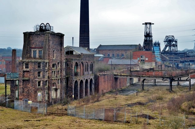 After coal production stopped at Chatterley Whitfield in 1977, a brave venture was started by an
independent charitable trust to turn the colliery into Britain’s first underground mining museum.
The problem was it relied on nearby Wolstanton Colliery to pump its water out there by keeping the
natural water table low. When Wolstanton stopped coal production and its pumps were turned off in
1984, meant that the water present would gradually rise to its natural level and slowly flood
the abandoned Chatterley Whitfield. The cost of pumping was too high and could not be met by the museum.
The new Experience survived until the early 1990s, when it was put into the hands of the liquidators.
 -
Top Gear at Rudyard lake
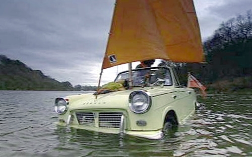 The BBC's motoring show Top Gear held a challenge at the lake in 2006 to see which presenter had
designed the best amphibious car. Richard Hammond's attempt sank while Jeremy Clarkson's attempt
capsized. However, James May's Triumph Herald, complete with sail and mast, performed well,
despite the almost total absence of wind, and he was able to drive it out of the water, thus winning the challenge.
 -
Mermaid's Pool
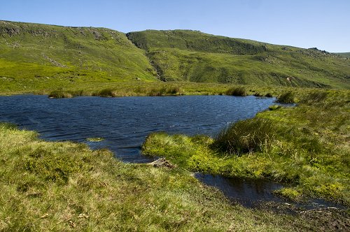 Believe it or not, but the land-locked Peak District is said to be home of a mermaid. She lives
in the appropriately named Mermaid's Pool, situated just below Kinder Scout in the High Peaks.
This site was thought to be popular for ancient Celtic water worship rituals, being salinated
water is a peculiarity for an inland lake. The waters of the Mermaid's Pool are believed to offer
healing qualities to those brave enough to bathe in them. For those looking for eternal life, the
best time to visit is at midnight at Easter.
 -
Wear a cycle helmet or not?
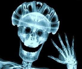 I was recently told, ‘if you don’t want to fall off then don’t ride a bike.’ The inference is at
some stage due to the inherent balance issues of being on two wheels as opposed to four; it’s
inevitably going to happen. so on to the subject of helmets; there are various debates as to whether
cycling helmets actually decrease the risk of a head injury during a crash. Indeed some of the helmets
I’ve seen kids wear; those which are ill fitted, loose, tilted too far back (or too far forward or
sideways), are more likely to add to the injury than prevent it. My crash was fairly unusual as the
jammed front wheel caused me to roll into the road landing on my shoulder first, most clavicle injuries
are caused by putting the hand out as an automated self preservation instinct, and my helmet. Well there's
a small dent on the right hand side and I can safely say that dent would have been on my head if I wasn’t
wearing one.

 Alton station was built in an Italianate villa style in about 1849. The station was used by the Earl
of Shrewsbury, and had a luggage lift to hoist the Earl's baggage up to the entrance to Alton Towers.
The station also comprised a three-storey tower which contained the Earl's suite of waiting rooms and its
platform was particularly long to satisfy the Earl's desire to have impressive surroundings in which to
receive his guests. In 1954 the station was renamed Alton Towers. After the line closed in the 1960s, the
station was acquired by the Landmark Trust.
  Since the 17th century, the area has been almost exclusively known for its industrial-scale pottery
manufacturing. Companies such as Royal Doulton, Dudson Ltd, Spode, Wedgwood, Minton and Baker & Co.
were established and based there. The local abundance of coal and clay suitable for earthenware production
led to the early development of the local pottery industry. The construction of the Trent and Mersey Canal
enabled the import of china clay from Cornwall together with other materials.
 Westport Lake used to be the site of Port Vale football club. The ground was originally Westport
Meadows, the club played there for three years, but the area was prone to flooding. Today there are
two lakes, with a path a mile long around them, the lakes provide a sanctuary for visiting birds from
all over the World.
 For over 100 years trains travelled along the Biddulph Valley Way carrying coal from the Collieries
around Stoke-on-Trent to Congleton. The railway line linked Stoke on Trent to Brunswick Wharf in
Congleton, with a branch joining the Macclesfield to Stafford main line at the viaduct. To avoid
travelling back to Staffordshire with empty wagons, sand was often transported into the Potteries
for industrial use, as this mineral was abundant around Congleton.
 After coal production stopped at Chatterley Whitfield in 1977, a brave venture was started by an
independent charitable trust to turn the colliery into Britain’s first underground mining museum.
The problem was it relied on nearby Wolstanton Colliery to pump its water out there by keeping the
natural water table low. When Wolstanton stopped coal production and its pumps were turned off in
1984, meant that the water present would gradually rise to its natural level and slowly flood
the abandoned Chatterley Whitfield. The cost of pumping was too high and could not be met by the museum.
The new Experience survived until the early 1990s, when it was put into the hands of the liquidators.
 The BBC's motoring show Top Gear held a challenge at the lake in 2006 to see which presenter had
designed the best amphibious car. Richard Hammond's attempt sank while Jeremy Clarkson's attempt
capsized. However, James May's Triumph Herald, complete with sail and mast, performed well,
despite the almost total absence of wind, and he was able to drive it out of the water, thus winning the challenge.
 Believe it or not, but the land-locked Peak District is said to be home of a mermaid. She lives
in the appropriately named Mermaid's Pool, situated just below Kinder Scout in the High Peaks.
This site was thought to be popular for ancient Celtic water worship rituals, being salinated
water is a peculiarity for an inland lake. The waters of the Mermaid's Pool are believed to offer
healing qualities to those brave enough to bathe in them. For those looking for eternal life, the
best time to visit is at midnight at Easter.
 I was recently told, ‘if you don’t want to fall off then don’t ride a bike.’ The inference is at
some stage due to the inherent balance issues of being on two wheels as opposed to four; it’s
inevitably going to happen. so on to the subject of helmets; there are various debates as to whether
cycling helmets actually decrease the risk of a head injury during a crash. Indeed some of the helmets
I’ve seen kids wear; those which are ill fitted, loose, tilted too far back (or too far forward or
sideways), are more likely to add to the injury than prevent it. My crash was fairly unusual as the
jammed front wheel caused me to roll into the road landing on my shoulder first, most clavicle injuries
are caused by putting the hand out as an automated self preservation instinct, and my helmet. Well there's
a small dent on the right hand side and I can safely say that dent would have been on my head if I wasn’t
wearing one.